
Athol Parks and Greenway Network
Overview
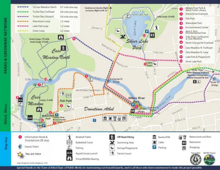
This park network consists of easy-to-moderate walks and hikes in and around Downtown Athol. Our public green spaces are truly unique sites for relaxation, recreation, and connection to the natural world. The Millers River continues to be a vital resource for our town and region.The parks features in the network are both state and locally owned.
Located behind the new Athol Public Library along a 326 foot river wall, the new Millers River Park serves as the head of the downtown riverway.
Initial funding for the Millers River Park and the Greenway Network comes from a Massachusetts PARC Grant, Friends of the Athol Public Library, and the Town of Athol.
The trail map depicts a series of short intra-community walking/jogging/biking trail loops, beginning at the end end of the park network at Millers River Park and connects with Fish Park, Alan E. Rich Environmental Park, Silver Lake Park, and a number of scenic river overlooks.
Interpretive Features
In conjunction with AOTV, we've recruited area naturalists and historians to create videos for ten of the parks located on the map. Learn about the ecology and history of these sites.
At each kiosk (or main park sign), you will find scannable QR codes. These will take you directly to the website and individual park webpages. Simply download a free QR Code Reader on your smartphone.
Lending Library
A lending library of nature-related matierals are available at the Athol Public Library, including binoculars and butterfly nets for nature study, and water nets for pond and river exploration.
Check with the Library for more information, including hours and availability.